DC Road Runners - Enter your slogan here
|


Welcome! This is the home of the world-famous (well, maybe locally well-known) SLR.
Our start time is at 8:00 AM for the rest of the year. Every Saturday we meet at North Meade Street Park, a small park northwest of the USMC War Memorial (Iwo Jima Memorial) in Rosslyn. The closest address for mapping purposes is 1300 Arlington Blvd, and street parking is available in the neighborhoods adjacent to N. Meade Street. Be mindful of parking signs, since Arlington County enforces them enthusiastically, and please do not park on Marine Memorial Circle (inside Iwo Jima), because this parking area is for memorial use only. At least one porta-john is available year-round near the Iwo Jima Memorial, and the memorial's water fountain is usually on during the summer.
We run rain or shine! In cases of extreme weather (snow, ice, thunderstorms, heat waves) we do occasionally either change our meeting time or cancel the run for safety, but the run will be held as planned unless otherwise posted via email/twitter/facebook and here on the SLR web page.
All are welcome! We're an informal group, and there are no requirements for speed, racing experience, or what distance means "long" for you, other than the suggested route that most of our group will be running each week. If you don't want to run the same distance or course as the main group, you can go out for half of your own target distance and re-trace your steps back to Iwo Jima. More specific route info and mileage options will be given in the email/post preceding each Saturday's run. SLR always features a run from our extensive Route Catalog, which gives us a wide range of options to keep things fresh for you each week. We have routes that are flat, hilly, looped, out & back, roads, sidewalks, trails, and more, reaching all around the local area of DC, VA, and MD!
For more details about Saturday Long Runs please read our Frequently Asked Questions to get a sense for what it's like to run with us, or send an email to Anna if you have any other questions that are not covered.
To receive weekly SLR updates via email, please log in and check your email subscriptions.
Schedule:
| Date | Miles | Route Map | Navigation Downloads | Post/Mid-Run Beverages |
| 4/20 | 18 | Arboretum - Azaleas!! | Cue Sheet & GPS | |
| 4/27 | 12 | Piney Branch | Cue Sheet & GPS | |
| 5/4 | 14 | MBT - Catholic | Cue Sheet & GPS | |
| 5/11 | 14 | Capital Crescent OaB | Cue Sheet & GPS | |
| 5/18 | 16 | Arlington Loop | Cue Sheet & GPS | |
| 5/25 | 14 | Battery Garesche | Cue Sheet & GPS |
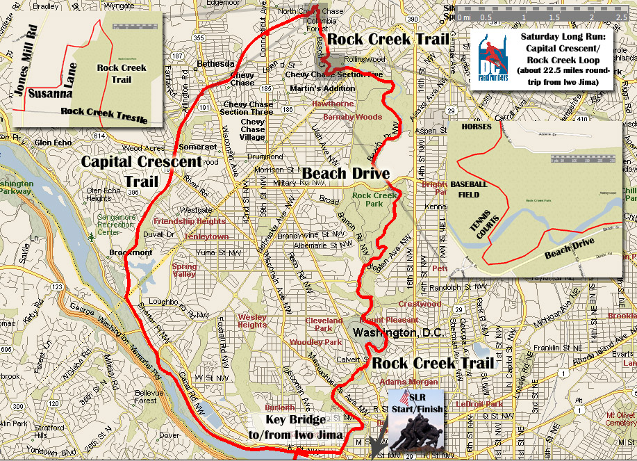
SLR Feb 25 - Cap Crescent to Rock Creek BIG Loop (CW)
Hello Saturday Runners!
This is it – the BIG one! This Saturday, Feb 25th, we will be running the Capital Crescent to Rock Creek BIG Loop (Clock-Wise direction). The standard loop is over 23 miles total – I also created a 21.5 mile version in map-my-run, so please review the appropriate links in the directions section for full details.
Thank you to Walter Barrett for once again taking care of our post-run beverages. We will need more volunteers soon. Although March is covered, we do need someone for March 17th, April, and beyond. Email slr@dcroadrunners.org if you can help out.
Directions: Please review the cut sheet, big map, and/or map-my-run map for details on the full 23.25 mile Loop. If you would rather do the 21.5 mile version check out this map-my-run map for a slight detour (after opening map, click “Cute Notes” for additional written prompts). The detour basically cuts off the top of the loop by going through a Chevy Chase neighborhood before meeting back up with Rock Creek Park trails and Beach Drive.
More Approx. Mileage Options (make it an out-and-back)
- 10: Turn around at 5 miles out, mile marker 6.5 (water fountain here)
- 16: Turn around at 8 miles out, mile marker 3.5, right before entering Bethesda (water fountain on left)
Check the bottom of the cue sheet page for more water fountain listings (most seem to be on from what I have seen lately).
We are about 3 weeks out from the National "Rock-n-Roll" DC Marathon, and 7 weeks out from Boston! Happy Running!
-- Erik
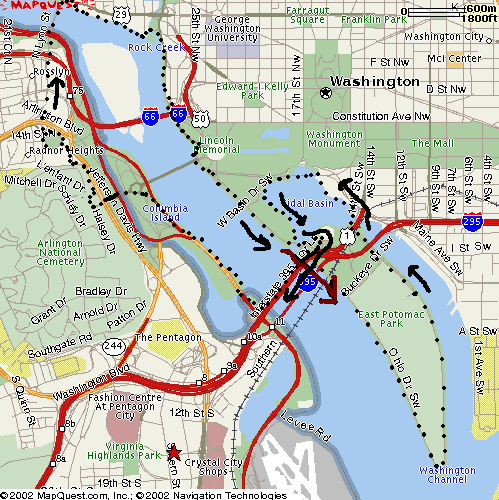
SLR Feb 18 - Water Route
Hello Saturday Runners!
This Saturday, Feb 18th, we will be running the Water Route; its 12 miles or easily modified for 17 in these directions. Check out the big map or map-my-run map for clarification. Directions to follow.
Thank you to Walter Barrett for taking care of our post-run beverages. We will be needing more volunteers soon – email slr@dcroadrunners.org if you can help out. Although March is covered, we do need someone for March 17th . That's the day of the National "Rock-n-Roll" Marathon and Half Marathon in DC, so we are expecting a light load and it shouldn't be much work. Again, email if you can help out.
The GW Birthday Marathon (a DCRRC race) is Sunday and they could still use volunteers. Please contact Audrey Perlow if you can help.
Directions: Begin at Iwo Jima. Run through Rosslyn across Key Bridge toward Georgetown. Sharp RIGHT after bridge down to river side of C&O Canal. LEFT on C&O Towpath and QUICK RIGHT down steps to K St. LEFT on K St Eastbound toward the Washington Harbor. ZIGZAG RIGHT and LEFT to get onto the path fronting river (heading downstream). Pass by left side of Thompson Boat Center and take a RIGHT at the Rock Creek Trail, passing Watergate and Kennedy Center. Continue on Rock Creek Trail past Lincoln Memorial, visit Lincoln is desired. After running under the Memorial Bridge, STAY to the right and follow the path between Ohio Drive roadway and the river. Continue running past 14th Street Bridge and counter clockwise around Hains Point. Pass under some overpasses to arrive at the Tidal Basin. Turn RIGHT and circle the Tidal Basin counterclockwise, eventually passing the new MLK memorial. After passing FDR, turn LEFT on East Basin Drive, cross the street, run ~100 yards and turn HARD RIGHT up the incline to the 14th Street Bridge back to Virginia. At end of 14th St. bridge take left on Mt. Vernon trail, run down to the end of DCA, turn around at intersection with 4 Mile run trail. Head back to Iwo Jima via memorial Bridge.
Heated bathrooms with running water under the Lincoln Memorial and under the Jefferson Memorial.
Approx. Mileage Options:
9: Skip the loop around Hains Point (While on Ohio Drive, take left on East Basin Drive and do the loop around the Tidal Basin, then take 14th street bridge back to VA)
12: Follow cut sheet exactly, come back to Iwo Jima via a right onto Mt. Vernon trail after 14th St. bridge
17: After taking 14th Street bridge back into VA, run out to the end of DCA and turn around
Looks like great running weather Saturday morning, high 30s and partly cloudy!
-- Erik
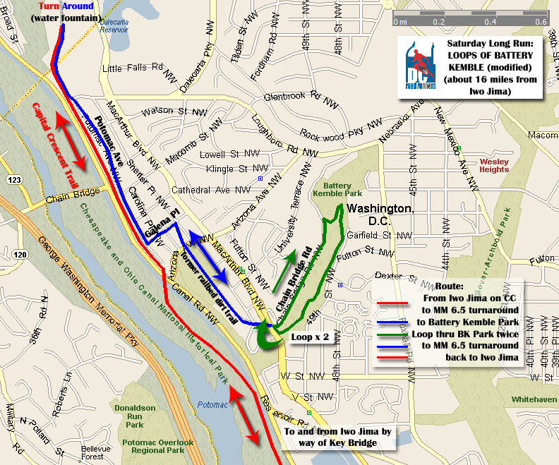
SLR Feb 11 - Loops of Battery Kemble
This Saturday, Feb the 11th, we will be running the Loops of Battery Kemble route. The suggested mileage is 14 miles; mileage options are provided after the directions. You might want to check out the big map too.
Thank you to Walter Barrett for our post-run drinks. We are always looking for volunteers for future months and typically try to have people do 1 month at a time. Email slr@dcroadrunners.org if you can help out.
A few notes on races: we are currently 1 week out from the GW Birthday Marathon (a DCRRC race), 5 weeks out from the National “Rock-n-Roll” DC Marathon & Half-Marathon, and 9 weeks out from Boston. Hope everyone is on track!
Directions: Begin at Iwo Jima, cross key bridge down to C&O Canal path but then go left and take a quick right down the steps to Water St. Right on Water St. to Capital Crescent Trail (paved trail). Continue (past Fletcher’s Boat House) on Cap Crescent. Just past MM 6.5 U-Turn at water fountain, now after about 1/4 mile from U-turn, take left onto trail with chain link fence on left to Potomac Ave. Follow Potomac Ave., then left on Galena Place. Take right onto former railbed dirt trail (or take MacArthur Blvd if you miss it). Now being loops of Battery Kemble Park: Go up Chain Bridge Rd (HILL), right onto gravel road, right onto trail at bottom of hill, stay on trail through woods and exit onto MacArthur Blvd. Take MacArthur back to base of Chain Bridge (1 loop complete) . Retrace your steps back to Cap. Crescent Trail, turn LEFT on trail (don’t go to U-turn spot). Continue back to Georgetown and across Key Bridge through Rosslyn to Iwo Jima. Thats 14 miles.
There are bathrooms at Fletcher’s boat house on the other side of the canal.
Approx. Mileage Options:
-
10: Turn around at MM 6.5 at Water-fountain, making the U-turn but just coming back from there
-
12.75: Don’t do any loops of Battery Kemble, turn around once you get to base of Chain Bridge Rd.
-
16: Do route as written in cue sheet (2 loops, then run out to MM 6.5 on the way back)
-
??: Add on loops of Battery Kemble to lengthen run (each loop is ~ 1.25 miles)
Have a great run!
-- Erik
More Articles...
- SLR Feb 4 - Rock Creek out and back
- SLR Jan 28 - Mt. Vernon Trail out & back
- SLR - Winter Weather Policy
- SLR Jan 21 - DC Sightseer Loop - TENTATIVE pending weather
- SLR Jan 14 - Mt. Vernon/ Hains Point "T"
- SLR Jan 7 - Marymount Chain Bridge Loop
- SLR Dec 31 - Pentagon Army Navy Dr.
- SLR Dec 24 - Holiday "Festivus" Run
Upcoming Events
| DCRRC Women's Distance Festival 5K and Run After the Women 5K Sun, Jun 9th, 2024, @8:00am |
| Book Club Sun, Jun 16th, 2024, @4:00pm |
| DCRRC Hugh Jascourt 4-Miler Fri, Jun 21st, 2024, @7:00pm |
| DCRRC Age Handicapped 4-Miler Thu, Jul 4th, 2024, @8:00am |
| DCRRC Bluemont 5K Wed, Jul 24th, 2024, @7:00pm |
Login
 |
The DC Road Runners Club is a member of the Road Runners Club of America and is also affiliated with USA Track & Field. We provide a year-round schedule of running events that offer everyone a chance to participate regardless of age, gender, or athletic ability. |