DC Road Runners - Enter your slogan here
|


Welcome! This is the home of the world-famous (well, maybe locally well-known) SLR.
Our start time is at 7:00 AM for the remainder of the summer! Every Saturday we meet at North Meade Street Park, a small park northwest of the USMC War Memorial (Iwo Jima Memorial) in Rosslyn. The closest address for mapping purposes is 1300 Arlington Blvd, and street parking is available in the neighborhoods adjacent to N. Meade Street. Be mindful of parking signs, since Arlington County enforces them enthusiastically, and please do not park on Marine Memorial Circle (inside Iwo Jima), because this parking area is for memorial use only. At least one porta-john is available year-round near the Iwo Jima Memorial, and the memorial's water fountain is usually on during the summer.
We run rain or shine! In cases of extreme weather (snow, ice, thunderstorms, heat waves) we do occasionally either change our meeting time or cancel the run for safety, but the run will be held as planned unless otherwise posted via email/twitter/facebook and here on the SLR web page.
All are welcome! We're an informal group, and there are no requirements for speed, racing experience, or what distance means "long" for you, other than the suggested route that most of our group will be running each week. If you don't want to run the same distance or course as the main group, you can go out for half of your own target distance and re-trace your steps back to Iwo Jima. More specific route info and mileage options will be given in the email/post preceding each Saturday's run. SLR always features a run from our extensive Route Catalog, which gives us a wide range of options to keep things fresh for you each week. We have routes that are flat, hilly, looped, out & back, roads, sidewalks, trails, and more, reaching all around the local area of DC, VA, and MD!
For more details about Saturday Long Runs please read our Frequently Asked Questions to get a sense for what it's like to run with us, or send an email to Anna if you have any other questions that are not covered.
To receive weekly SLR updates via email, please log in and check your email subscriptions.
Schedule:
| Date | Miles | Route Map | Navigation Downloads | Post/Mid-Run Beverages |
| 5/31 | 15 | Long Bridge Park | Cue Sheet & GPS | |
| 6/7 | 13 | Iron Triangle | Cue Sheet & GPS | |
| 6/14 | 12 | Four Mile Run Park | Cue Sheet & GPS | |
| 6/21 | 14 | Capital Crescent OaB | Cue Sheet & GPS | Post: Kate Scott |
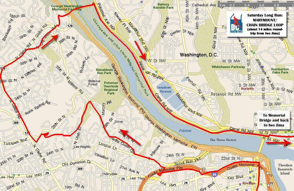
| 6/28 | 13 | Marymount Chain Bridge | Cue Sheet & GPS | Post: Kate Scott |
| 7/5 | 14 | MBT - Catholic | Cue Sheet & GPS | |
| 7/12 | 12 | RFK | Cue Sheet & GPS | |
| 7/19 | 14 | Ross Drive | Cue Sheet & GPS | Post: Kate Scott |
| 7/26 | 14 | Capital Crescent OaB | Cue Sheet & GPS | Post: Kate Scott |
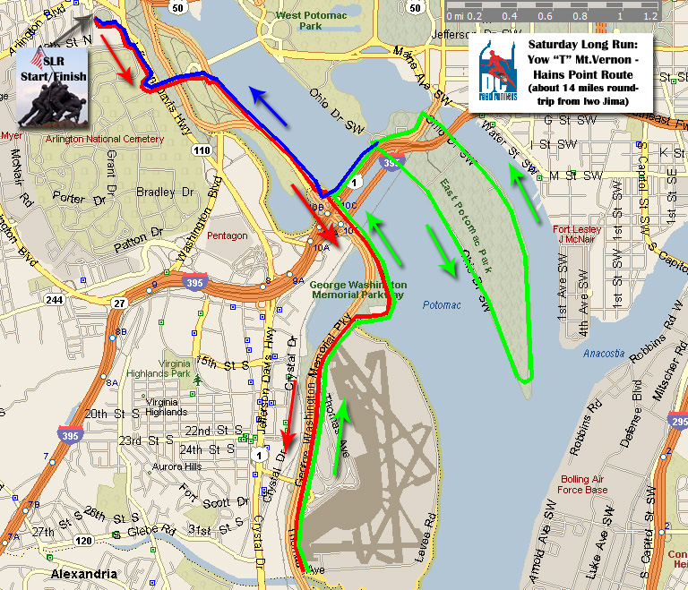
SLR Jan 14 - Mt. Vernon/ Hains Point "T"
Hello Saturday Runners!
This Saturday, Jan 14th, we will be running the Mt. Vernon/ Hains Point "T" route. The listed mileage this week is 18 miles – the route map / cue sheet is for 14, so do an extra loop around Hains point to get ur long run in! More mileage options are provided after the directions. Please thank Kevin Cunningham for once again providing post-run beverages.
Directions: Begin at Iwo Jima, take Mt. Vernon Trail south, crossing Memorial Bridge (mileage options begin here – see below), continue past Gravelly Point park (this is where the airplanes take-off). Turn around at Four Mile Run, just past the airport. Now heading North on Mt. Vernon trail - just after the 14th St. bridge, loop left to cross the 14th St. bridge. At the end of the bridge, turn left 180 degrees down stairwell to Ohio Dr. After going down Hains Point and back up the other side, turn left on East Basin Drive, then Left on Ohio Drive and do another loop around Hains Point. After 2nd loop, turn left to go past Jefferson Memorial, and take walkway up to 14th St. Bridge. Cross back over 14th St. bridge, take Mt. Vernon trail north and finish at Iwo Jima. There are some port-a-potties at Gravelly Point fyi.
Approx. Mileage Options
- 8: Go directly across 14th St. bridge (do NOT run down to Gravelly Point) to Hains Point, do 1 loop
- 10: Turn around at Gravelly Point, continue with cues (1 loop around Hains Point)
- 14: Do as written in cue sheet (1 loop around Hains Point)
- 18: After your first loop around Hains Point, take Left on East Basin Drive, then Left on Ohio Drive and do another loop! (each loop around Hains Point is approx. 4 miles)
I remember having the sun in my eyes a lot on this route, so if its clear out sunglasses or a hat might be a good idea. Have a good run, and dress warm! But not too warm…
-- Erik
SLR Jan 7 - Marymount Chain Bridge Loop
Hello Saturday Runners!
This Saturday, Jan. 7th (First SLR of 2012!), we will be running the Marymount Chain Bridge Loop Route. The listed route mileage is 14 miles. Check the cue sheet and map for full details.
Please thank Kevin Cunningham for our post-run Beverages. Fortunately people have been stepping up for drinks but more volunteers are always welcome. Ideally, you could cover a whole month to keep logistics easy, but you can split the month with someone else if need be. Email slr@dcroadrunners.org if you can help out.
I am going to continue to get the SLR updates out Thursdays now instead of Fridays just to give people a little more heads up, so watch your inbox. Don’t forget the EPIC Happy Hour with DCRRC at Whitlows on Wilson, Thurs. Jan 19th!
Directions: From Iwo Jima, go through Rosslyn and take Custis Trail West, just after crossing bridge over Spout Run Pkwy, turnoff sharp left, go under bridge and turn left on bike trail to Lorcum Lane. Right on Nellie Custis Dr (hill), becomes Military Rd. 400 meters after Marcey Street, by fire hydrant, turn left into Zach Taylor Park. Take trail up hill through park. Trail opens on two roads (Vermont and Vernon), cross and stay on paved trail. Turn left on 26th, running by Marymount College, right on Old Dominion, veer right on Glebe Rd. Take right on N. Old Glebe Rd, staying right of white church, just past Military road follow green bike route signs, turn right on Old Glebe and quick Left on N. Randolph, take steep hill down to Chain Bridge and cross on left side, now take walkway on left to C&O Canal towpath. Return towards Georgetown next to the water (bathroom at Fletcher's boat house). At the end of Georgetown, take right on Rock Creek Trail, taking Memorial Bridge back to Iwo Jima.
Mileage Options:
- 9: Continue on Military Road to N. Old Glebe Rd. (Don't turn left into Park), cutting off the Marymount college portion, return to Iwo Jima via Key Bridge
- 11: Continue on Military Road to N. Old Glebe Rd. (Don't turn left into Park), cutting off the Marymount college portion, return to Iwo Jima via Memorial Bridge
- 12: Do route as written but return to Iwo Jima via Key Bridge
- 17: After you get back, do a loop from Rosslyn, over Key Bridge, past Kennedy Ctr and back via Memorial Bridge for about 3 extra miles
Have a great run! Keep your fingers crossed for more great running weather on the weekends!
-- Erik
SLR Dec 31 - Pentagon Army Navy Dr.
Hello Saturday Runners!
This Saturday, Dec. 31st, we will be running the Pentagon – Army Navy Dr. Route. As it is written the route is 12 miles but we will be adding some loops around Roosevelt Island to tack on a few extra miles (do 3 loops for 16 miles).
Please thank Kevin Cunningham for our post-run Beverages. We are covered for drinks through January, but could always use volunteers for February and beyond. Its not a lot of work and DC Roadrunners reimburses you for costs. Email slr@dcroadrunners.org if you can help out.
Directions: From Iwo Jima, go towards Memorial Bridge heading to Mt. Vernon Trail. After traffic circle, go to the right of bridge and STAY STRAIGHT on trail on left side of Rt. 27 (DO NOT go to Mt. Vernon Trail). Follow path/sidewalk along Rt. 27 past the Pentagon. After Pentagon, BEAR LEFT through South Parking Lot and go through long pedestrian tunnel under 395. Quickly turn RIGHT on Army Navy Dr. up hill. Road becomes Adams Dr. then ends on Glebe Rd. Cross Glebe Rd. and go LEFT on Four Mile Run Trail. Trail ends at Mt. Vernon Trail, take Mt. Vernon North Past DCA. Continue on Mt. Vernon Trail (adding optional loops around Roosevelt Island; 2 or 3 is suggested – see below), once in Rosslyn go left on Lynn street and finish at Iwo Jima.
Mileage Options:
- For 7.5 miles: just after you pass the Pentagon, start circling around through the South parking lots, making your way to the sidewalk by N Boundary Channel Drive. With the Pentagon still in view (now behind you), take the footbridge over the river toward the Columbia Island Marina. Stay on this path through a tunnel under GW Parkway to connect with Mt. Vernon Trail. Continue North on Mt. Vernon trail back to Iwo Jima.
- Do route as written in cue sheet for 12 miles.
- Each Loop around Roosevelt Island is approx. 1.5 miles, so do 1 loop for 13.5 miles total, 2 loops for 14.75 miles total, or 3 loops for 16 miles total, and so on if you need even more.
I am going to try to get the SLR updates out Thursdays now instead of Fridays just to give people a little more heads up, so watch your inbox.
Have a great run! And Happy New Year!
-- Erik
More Articles...
Upcoming Events
| Women's Distance Festival and Run After The Women Sun, Jun 8th, 2025, @8:00am |
| June Happy Hour and 2024-2025 Snowball Series Award Thu, Jun 19th, 2025, @6:00pm |
| Rock Creek 5K Sun, Jun 22nd, 2025, @8:00am |
| Age-Handicapped 4-Miler Fri, Jul 4th, 2025, @7:00am |
| Bastille Day 5K Mon, Jul 14th, 2025, @6:00pm |
| Bluemont 5K Wed, Aug 13th, 2025, @6:00pm |
Login
 |
The DC Road Runners Club is a member of the Road Runners Club of America and is also affiliated with USA Track & Field. We provide a year-round schedule of running events that offer everyone a chance to participate regardless of age, gender, or athletic ability. |