See larger version of course map.
As its name suggests, this route is HILLY! Enjoy. ;-) From Iwo Jima (mileage is approximated) 0.0 Begin
at Iwo Jima 0.5 Turn LEFT onto Custis Trail toward
W&OD (Be careful crossing this intersection.) 4.5 Turn RIGHT at trail spur just before
Mile Marker 0.0. The spur will be at the bottom of a hill and immediately
before the trail goes under I-66. (If you get to the gazebo at the intersection
of W&OD, you have gone too far) 4.75 Turn LEFT onto N. 11th St. 5.0 Turn LEFT onto Patrick Henry Drive
6.0 Upton Hill Regional Park (Restrooms
and water may be available) 6.0 This route is out-and-back. Circle parking lot and begin
retracing your steps back down Patrick Henry Dr. 7.0 Turn RIGHT onto N. 11th St. 7.25 Turn RIGHT onto N. Kennebec St. 7.5 Turn LEFT onto Custis Trail 11.5 Turn RIGHT on N. Lynn St. 12.0 Arrive Iwo Jima. 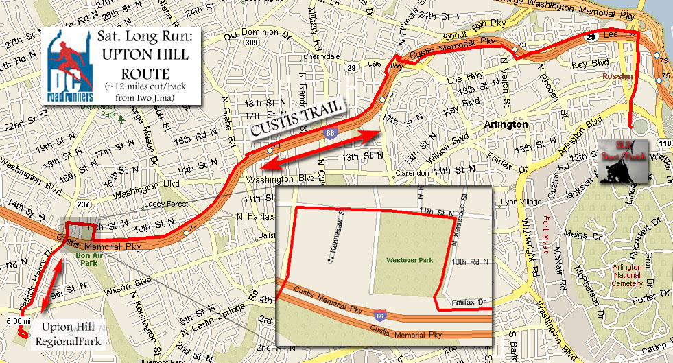
http://www.nvrpa.org/uptonhill.html
Go through Rosslyn toward Key Bridge
Keep Westover Park on your left (Restrooms and water may be available) and
follow N. Kennebec St.
There is a modest uphill here, but the "best" is yet to come.
Now the fun really begins.
Be careful crossing Wilson Blvd. You will be tired.
This last hill is the worst, I promise.
Did you have fun today?