See larger version of course map.
See larger version of course map.
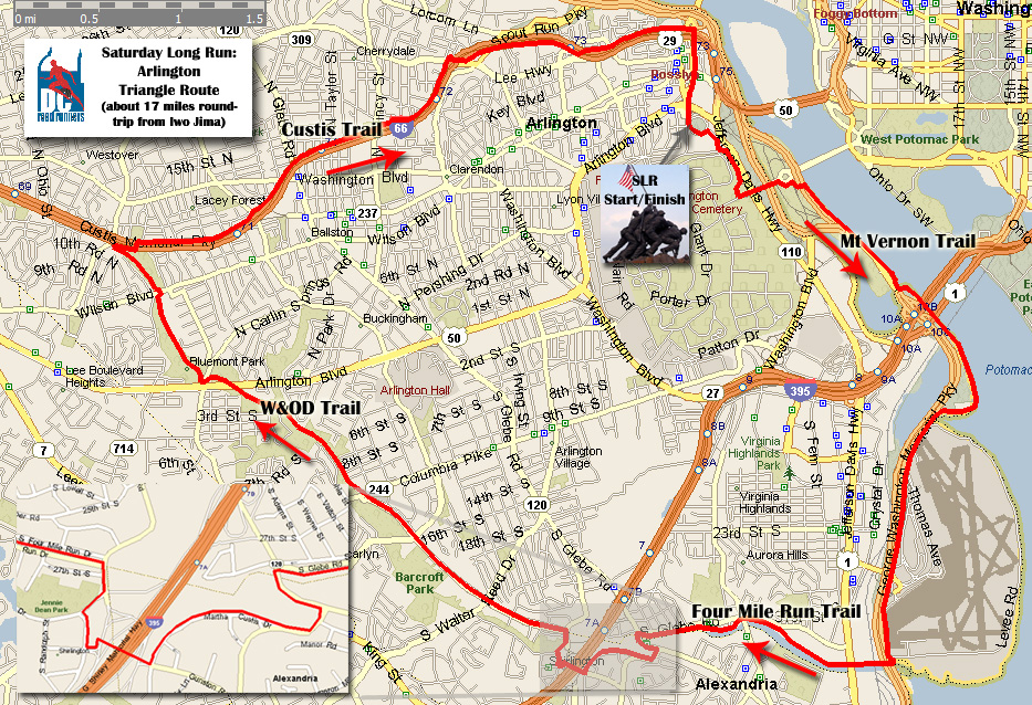
Miles (approximate) 0.0 Begin at Iwo Jima, follow bike path toward Memorial Bridge. 1.0 From Memorial Bridge follow Mt.Vernon trail south past National Airport. 5.0 Veer left onto Four Mile Run Trail. Proceed through underpasses (~ 5 underpasses within ¼ mile, with Rte 1 being the last underpass). Run along north side of Four Mile Run. 6.6 Take left onto West Glebe (End of Four Mile Trail). West Glebe is the second road crossing Four Mile Run after Rte 1. Shirlington HorseShoe to W&OD Trailhead 6.8 Take first Right onto Valley Road 6.9 Veer Right onto Martha Custis Rd. 7.3 Take Pedestrian Bridge over 395 7.6 Right onto 28th Street followed by immediate Right onto S. Quincy 7.7 Right onto S. Arlington Mill 7.75 Left onto S. Shirlington. Run past the Weanie Beanie on your left. 7.8 Left onto W&OD Trailhead (MileMark 0). Trailhead marked by big brown sign. Follow W&OD trail for just under 4 miles. 11.7 Right at Gazebo in Bon Air Park and before W&OD MileMark 4. After ~100 yards, take first Left onto Custis Trail and proceed under I-66. Follow Custis Trail to Rosslyn. 16.3 Right onto Lynn Street 17.0 Arrive at Iwo Jima Known Bubblers / Water Jennie Dean Park (S. Quincy & S Arl. Mill) Bluemont Park (W&OD MileMark 3.5) Bon Air Gazebo (W&OD MileMark 4) 50 yards further at Custis Trailhead Custis Trail ~ 2 mile mark Freedom Park (Lee and Key Hwys) Optional: At 7.7 miles into run, take a Left onto S. Arlington Mill. Find and follow the Four Mile Run Trail (Paved, windy & hilly trail through the woods). This trail links back up with W&OD trail prior to the Gazebo. A few bubblers located along Four Mile Run Trail.